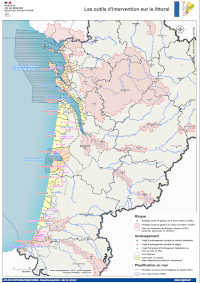
Nouvelle-Aquitaine : outils d'intervention sur le littoral - atlas DREAL 2021
Outils d'intervention sur le littoral pour les risques, l'aménagement et la planification en mer.
Simple
Identification info
- Date
- Citation identifier
- https://catalogue.sigena.fr/geonetwork/srv/3612f487-5034-4825-af3e-dd7b001e4dcc
- Point of contact
-
Organisation name Individual name Electronic mail address Role DREAL Nouvelle-Aquitaine
Mission Connaissance et Analyse des Territoires
Point of contact
-
INSPIRE Service taxonomy
-
-
infoMapAccessService
-
-
GEMET - INSPIRE themes, version 1.0
-
-
Zones de gestion, de restriction ou de réglementation et unités de déclaration
-
-
Régions de France
-
-
NOUVELLE-AQUITAINE
-
- Keywords
-
- Classification
- Unclassified
- Service Type
- invoke
- Description
-
Nouvelle-Aquitaine
))
- Coupling Type
- Tight
- Contains Operations
-
Operation Name Distributed Computing Platforms Connect Point Accès au fichier contexte OWS de la carte
Web services https://carto.sigena.fr/context/getOws/73051664 Accès à la carte interactive
Web services https://catalogue.sigena.fr/geosource/consultation?id=73051664
- Reference system identifier
- EPSG / RGF93 / Lambert-93 (EPSG:2154) / 7.4
- Units of distribution
-
liens associés
- OnLine resource
-
Protocol Linkage Name WWW:LINK-1.0-http--link
https://catalogue.sigena.fr/geosource/consultation?id=73051664 Accès à la carte
WWW:LINK-1.0-http--link
https://carto.sigena.fr/context/getOws/73051664 Accès au fichier contexte OWS de la carte
WWW:LINK-1.0-http--link
https://carto.sigena.fr/export/getPdf?id=73051664 Accès au fichier PDF de la carte
- Hierarchy level
- Service
- Statement
-
Données : INSEE RP2018, IGN admin express 2021.
Réalisation : DREAL NA
Metadata
- File identifier
- 3612f487-5034-4825-af3e-dd7b001e4dcc XML
- Metadata language
-
fre
- Character set
- UTF8
- Hierarchy level
- Service
- Hierarchy level name
-
service
- Date stamp
- 2022-02-04T16:10:32
- Metadata standard name
-
ISO 19115:2003/19139
- Metadata standard version
-
1.0
- Metadata author
-
Organisation name Individual name Electronic mail address Role DREAL Nouvelle-Aquitaine
Mission Connaissance et Analyse des Territoires
Point of contact
Overviews
Spatial extent
Provided by
