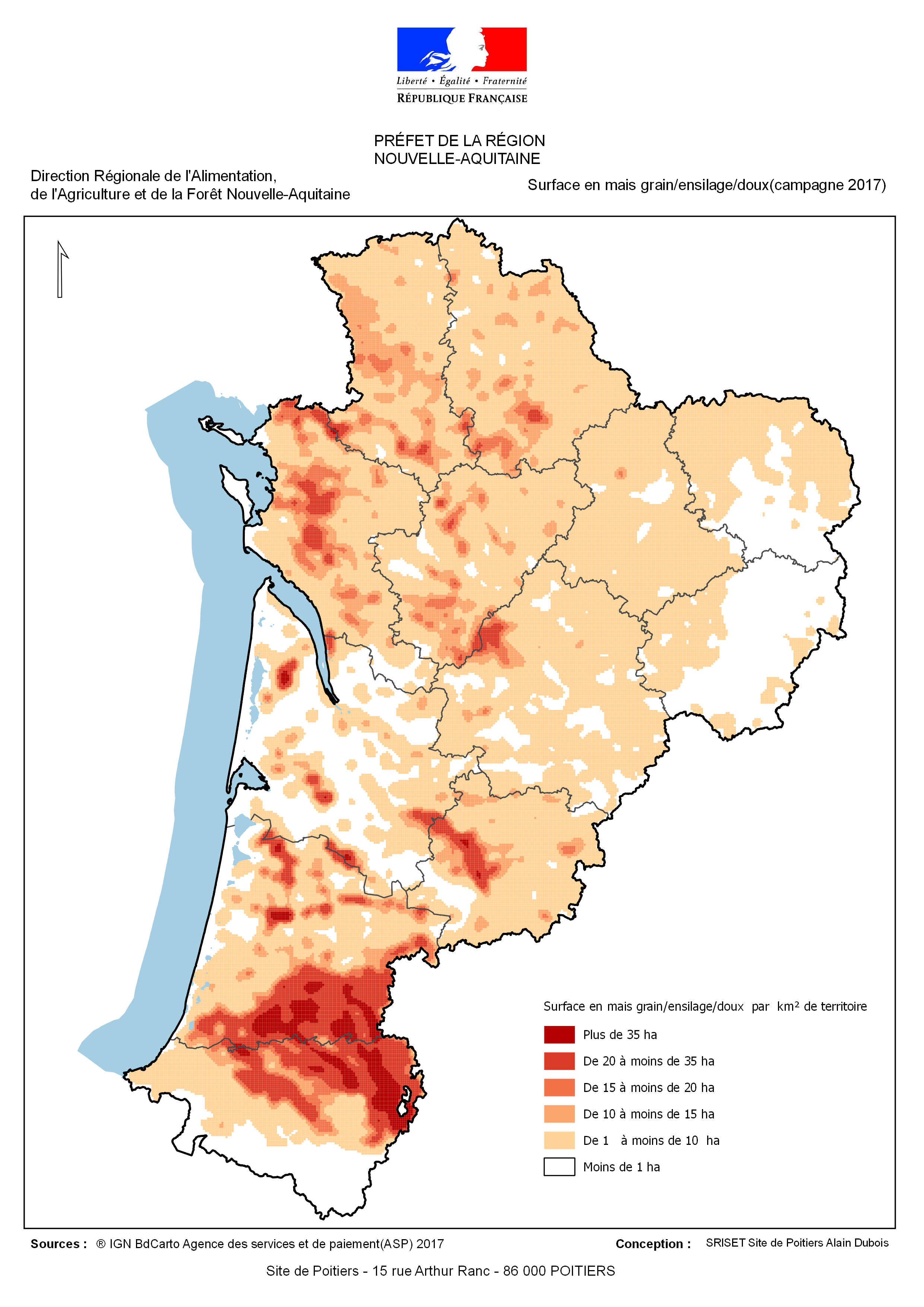
Nouvelle Aquitaine : Les surfaces semées en mais durant la campagne 2017
Cette carte permet de visualiser la surface semée en mais (MIS : mais grain-semence , MID : mais doux, MIE : mais ensilage) durant la campagne 2017 (Registre parcellaire graphique fourni par l'ASP pour cette campagne). L'estimation de la surface en mais a été estimée en utilisant une méthode de lissage (biweight) sur un rayon de 5 km répartie à une grille de 1 km de large et 1 km de long.
Simple
Identification info
- Date (Publication)
- 2018-12-17T05:05:00
- Citation identifier
- https://catalogue.sigena.fr/geonetwork/srv/4eb7baaf-ba62-4955-8b23-7002f5dbcefa
- Point of contact
-
Organisation name Individual name Electronic mail address Role DRAAF NOUVELLE AQUITAINE
alain dubois
Point of contact
-
INSPIRE Service taxonomy
-
-
infoMapAccessService
-
- Keyword
-
Agriculture
- Keyword
-
Grand public
- Keyword
-
Occupation du sol
- Keyword
-
DRAAF
- Keyword
-
Nouvelle-Aquitaine
- Type
- Theme
- Date (Publication)
- 2023-06-15
-
Régions de France
-
-
NOUVELLE-AQUITAINE
-
-
GEMET - INSPIRE themes, version 1.0
-
-
Occupation des terres
-
- Keyword
-
Grand public
- Keyword
-
DRAAF
- Keyword
-
Zonages agricoles
- Keyword
-
Agriculture-Environnement
- Keyword
-
Exploitation élevage
- Type
- Theme
- Date (Publication)
- 2023-06-15
- Keyword
-
Grand public
- Keyword
-
DRAAF
- Keyword
-
Zonages agricoles
- Keyword
-
Agriculture-Environnement
- Keyword
-
Exploitation élevage
- Type
- Theme
- Date (Publication)
- 2023-06-15
- Keyword
-
Grand public
- Keyword
-
DRAAF
- Keyword
-
Agriculture-Environnement
- Type
- Theme
- Date (Publication)
- 2023-06-15
- Keyword
-
Grand public
- Keyword
-
DRAAF
- Keyword
-
Agriculture-Environnement
- Type
- Theme
- Date (Publication)
- 2023-06-15
- Keyword
-
Grand public
- Keyword
-
DRAAF
- Keyword
-
Agriculture-Environnement
- Type
- Theme
- Date (Publication)
- 2023-06-15
- Keyword
-
Grand public
- Keyword
-
DRAAF
- Keyword
-
Agriculture-Environnement
- Type
- Theme
- Date (Publication)
- 2023-06-15
- Keyword
-
Agriculture-Environnement
- Keyword
-
DRAAF
- Keyword
-
Grand public
- Type
- Theme
- Date (Publication)
- 2023-06-15
- Classification
- Unclassified
- Service Type
- invoke
- Description
-
Nouvelle Aquitaine
))
- Coupling Type
- Tight
- Contains Operations
-
Operation Name Distributed Computing Platforms Connect Point Accès à la carte PDF
Web services Accès à la carte PDF
Web services Accès à la carte PDF
Web services Accès à la carte PDF
Web services Accès à la carte PDF
Web services Accès à la carte interactive
Web services Accès au fichier contexte OWS de la carte
Web services Accès à la carte interactive
Web services Accès au fichier contexte OWS de la carte
Web services Accès à la carte interactive
Web services Accès à la carte PDF
Web services /geosource/consultation?id=53043752 Accès à la carte PDF
Web services /geosource/consultation?id=53043752
- Reference system identifier
- EPSG / RGF93 / Lambert-93 (EPSG:2154) / 7.4
- Units of distribution
-
liens associés
- OnLine resource
-
Protocol Linkage Name WWW:LINK-1.0-http--link
/geosource/consultation?id=53043752 Accès à la carte
- Hierarchy level
- Service
- Statement
-
Cette carte a pour origine le fichier parcelle de l ASP (2016) . Elle a été créée en utilisant une méthode de lissage (biweight ) qui permet de lisser l'information sur un rayon de 5 km dans une maille de 1km de large et de 1km de long
Metadata
- File identifier
- 4eb7baaf-ba62-4955-8b23-7002f5dbcefa XML
- Metadata language
-
fre
- Character set
- UTF8
- Hierarchy level
- Service
- Hierarchy level name
-
service
- Date stamp
- 2019-01-17T10:39:58
- Metadata standard name
-
ISO 19115:2003/19139
- Metadata standard version
-
1.0
- Metadata author
-
Organisation name Individual name Electronic mail address Role DRAAF NOUVELLE AQUITAINE
Alain Dubois
Point of contact
Overviews

Spatial extent
))
Provided by
