Nouvelle-Aquitaine : plans de prévention des risques inondation et littoraux - atlas 2023
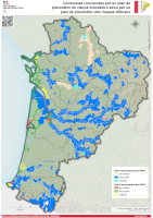
Communes concernées par un plan de prévention du risque inondation (PPRI) ou d'un plan de prévention des risques littoraux (PPRL) en Nouvelle-Aquitaine
Simple
Identification info
- Date
- Citation identifier
- https://catalogue.sigena.fr/geonetwork/srv/79c06f45-ac3d-4666-9bc5-14d3c4d9821e
- Point of contact
-
Organisation name Individual name Electronic mail address Role DREAL Nouvelle-Aquitaine
DREAL NA - Mission connaissance et analyse des territoires
Point of contact
-
INSPIRE Service taxonomy
-
-
infoMapAccessService
-
-
GEMET - INSPIRE themes, version 1.0
-
-
Zones à risque naturel
-
-
Régions de France
-
-
NOUVELLE-AQUITAINE
-
- Keywords
-
- Classification
- Unclassified
- Service Type
- invoke
- Description
-
Nouvelle-Aquitaine
N
S
E
W
))
- Coupling Type
- Tight
- Contains Operations
-
Operation Name Distributed Computing Platforms Connect Point Accès à la carte
Web services Accès à la carte interactive
Web services https://catalogue.sigena.fr/geosource/consultation?id=73054216
- Reference system identifier
- EPSG / RGF93 / Lambert-93 (EPSG:2154) / 7.4
- Units of distribution
-
liens associés
- OnLine resource
-
Protocol Linkage Name WWW:LINK-1.0-http--link
https://catalogue.sigena.fr/geosource/consultation?id=73054216 Accès à la carte
- Hierarchy level
- Service
- Statement
-
Fonds cartographiques IGN, données DREAL Nouvelle-Aquitaine
Metadata
- File identifier
- 79c06f45-ac3d-4666-9bc5-14d3c4d9821e XML
- Metadata language
-
fre
- Character set
- UTF8
- Hierarchy level
- Service
- Hierarchy level name
-
service
- Date stamp
- 2023-04-11T13:47:00
- Metadata standard name
-
ISO 19115:2003/19139
- Metadata standard version
-
1.0
- Metadata author
-
Organisation name Individual name Electronic mail address Role DREAL Nouvelle-Aquitaine
DREAL NA - Mission connaissance et analyse des territoires
Point of contact
Overviews
ppri.png
Spatial extent
N
S
E
W
Provided by

Associated resources
Not available