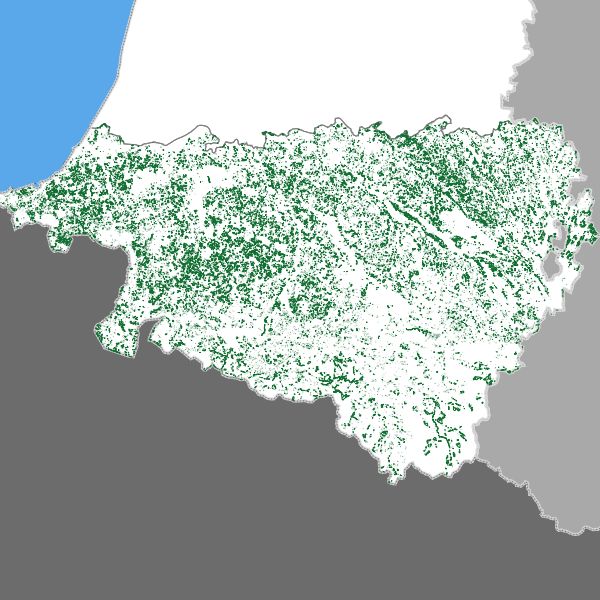
Pyrénées-Atlantiques : forêts disparues
Forêts présentes sur la carte d’Etat-major et actuellement disparues dans les Pyrénées-Atlantiques
Simple
- Date (Revision)
- 2021-05-11T10:57:54
- Date (Publication)
- Invalid Date
- Date (Creation)
- Invalid Date
- Date (Revision)
- Invalid Date
Point of contact
DREAL Nouvelle-Aquitaine
-
MICAT / Pôle information géographique
(
)
33 (0) 5 49 55 63 01
http://www.nouvelle-aquitaine.developpement-durable.gouv.fr/
15 rue Arthur Ranc BP 60539
,
Poitiers Cedex
,
86020
,
France
33 (0) 5 49 55 63 63
33 (0) 5 49 55 63 01
http://www.nouvelle-aquitaine.developpement-durable.gouv.fr/
- GEMET
-
- mot clé GEMET
- GEMET - INSPIRE themes, version 1.0
-
- Occupation des terres
- Theme
-
- forêt
- Départements de France
-
- PYRENEES-ATLANTIQUES
- Domaines
-
- Description
- Referentiel
- DREAL NA
- Grand public
- Access constraints
- Other restrictions
- Other constraints
- Pas de restriction d'accès public selon INSPIRE
- Denominator
- 40000
- Metadata language
- Français
- Character set
- UTF8
- Topic category
-
- Imagery base maps earth cover
- Description
- Pyrenees-Atlantiques
N
S
E
W
))
- Reference system identifier
- urn:ogc:def:crs:EPSG:6.11 / 2154 / 6.11
- Distribution format
-
-
ESRI Shapefile
(
version : 1.0
)
-
ESRI Shapefile
(
version : 1.0
)
- OnLine resource
- l_foret_disparue_s_d64 ( OGC:WMS-1.1.1-http-get-map )
- OnLine resource
- l_foret_disparue_s_d64 ( OGC:WFS-1.0.0-http-get-capabilities )
- OnLine resource
- l_foret_disparue_s_d64 ( OGC:WFS-1.0.0-http-get-capabilities )
- OnLine resource
- Accès au lien ATOM de téléchargement ( WWW:LINK-1.0-http--link )
- OnLine resource
- Accès au téléchargement des données ( WWW:DOWNLOAD-1.0-http--download )
- OnLine resource
- Accès à la visualisation des données ( WWW:LINK-1.0-http--link )
- Hierarchy level
- Dataset
Conformance result
- Date (Publication)
- Explanation
- cf. la spécification citée
- Pass
- No
- Statement
- Méthode de référence pour le géoréférencement et la vectorisation des minutes originales de la carte d’Etat-major au 1/40 000e, publiée sous forme d’article dans le numéro spécial de la Revue forestière française consacré aux forêts anciennes en 2017 (Lallemant Th., touzet Th., Gervaise A. – Une méthodologie nationale pour le géoréférencement et la vectorisation des cartes d’État-major – RFF, 2017).
- Feature catalogue citation
- File identifier
- af448920-384a-4665-ab73-bbd70be1581d XML
- Metadata language
- Français
- Character set
- UTF8
- Hierarchy level
- Dataset
- Date stamp
- 2021-11-10T14:43:14
- Metadata standard name
- ISO19115
- Metadata standard version
- 2003/Cor.1:2006
Point of contact
DREAL Nouvelle-Aquitaine
-
MICAT / Pôle information géographique
(
)
33 (0) 5 49 55 63 01
http://www.nouvelle-aquitaine.developpement-durable.gouv.fr/
15 rue Arthur Ranc BP 60539
,
Poitiers Cedex
,
86020
,
France
33 (0) 5 49 55 63 63
33 (0) 5 49 55 63 01
http://www.nouvelle-aquitaine.developpement-durable.gouv.fr/
Overviews

Aperçu
Spatial extent
N
S
E
W
))
Provided by

Associated resources
Not available
 Sigena